
During the COVID-19 pandemic, in-person site visits and local tours became much less common. But on a larger scale, the pandemic created extensive changes to how and where we work. As a result, many companies are taking a closer look at their real estate needs, while also evaluating where and how their employees work. The use of data points to help make informed business and real estate decisions has skyrocketed, with more weight placed on digital content and deliverables that help companies envision their future. One way companies have come to organize and address their data needs is through the adoption of Geographic Information Systems (GIS).
What is GIS?
Rooted in the science of geography, or “the science of where,” GIS are a framework for gathering, manipulating, analyzing, and visualizing data. GIS combine geographical features with non-geographical tabular data and transform this information into visualizations that map and assess real-world problems. GIS allow users to see business data like sales and locations on a map juxtaposed against demographic information, hydrography, parcel data and more, and can be leveraged to identify patterns, monitor market changes, and find opportunities to optimize business operations. In the real estate world, a GIS is a tremendous tool for providing insightful data that can push the industry forward.
GIS and Real Estate
Several major players in the real estate industry leverage GIS to find greater insights and take their service offerings to the next level. ESRI, Mapbox, LandVision, and open-source platforms like QGIS provide mapping and analytic solutions for professionals seeking geospatial insights, demonstrating the vital role of data in the industry. There are five key real estate practices that GIS have proven to be a game-changer for:
- Site Selection: It’s no secret that real estate is all about location and GIS are essential for locating property in a fast and uncomplicated manner. Advisors and account teams can find and visualize up-to-date information on available market opportunities fitting the suitability of clients’ needs, searching by various criteria such as price points or vacancy.
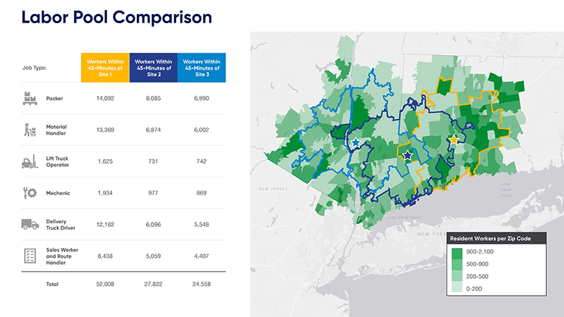
- Commute Impact & Labor Studies: An organization’s most important asset is its people. Understanding the labor strategy, growth projections, and how site selection and design will impact existing and future talent is critical to the success of any real estate transaction. GIS tools provide the ability to perform network and suitability analyses and develop in-depth site profiling of employee accessibility and the area’s utility to business operations.
- Land Sale Data: GIS have been used by various governments to publish land parcel information and county assessor data for years now. This allows for easier searching based on specifics that are outside traditional search terms. For instance, LandVision aggregates this data into a tool for advisors to identify a given parcel of land’s property value, acreage, sale date, owner information, and more.
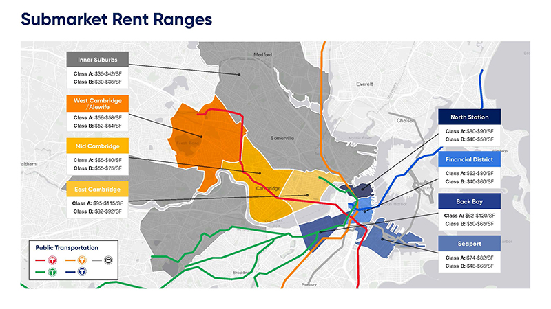
- Visual Communication: Sometimes it’s most important to see something to really comprehend it. Through the use of maps that visualize data like costs related to travel and employee location, GIS improve communications for real estate advisors, their clients, internal stakeholders and team members. Insights that may have been hidden deep in spreadsheets can become clear when presented visually, and mapping is an impactful way to show critical data and takeaways.
- Information Accessibility: Mobile-enabled web map applications and virtual tours allow for quick surveys of areas when clients are unable to see a location in-person. This has been a significant tool during the pandemic, as people were less able to travel to a location at a moment’s notice. GIS also allow for the layering of data, such as demographic information and crime statistics, providing all the information needed for decision-makers and in a format that allows for a clear comparison.
Map is for illustrative purposes only and may not reflect current market information.
If you’re interested in seeing how data can improve solutions for your organization, don’t hesitate to reach out to Cresa’s seasoned team of analysts. They have the expertise to utilize the latest technology and platforms to find insights and solutions that can help your company make informed business and real estate decisions.
-
Blog
What is Human-Centric Hybrid?
Our Human-Centric Hybrid event on Tuesday, March 19th elicited much discussion and debate from the audience. Many of those who attended are actively invested in developing hybrid and people-focused solutions for their businesses and brought their experiences and challenges to the discussion.
April 16, 2024 -
-